STREETLY,
STAFFORDSHIRE MEMORIES
(1936
- 1961)
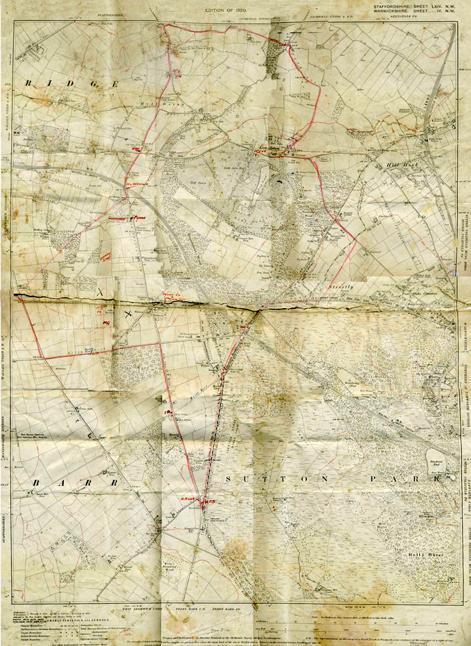
A MAP OF STREETLY
1920/1940
by Chris Myers
|
 This
is a map of Streetly
from 1920. Battered,
yellowed, torn and now
pieced together.
It has seen a bit of
service, especially in
its first 25 years of
life and that accounts
for its condition. It may be of
interest to anyone who
knows Streetly
in the 21st century because it's a
fascinating
map of an earlier
Streetly, on two
different levels. This
is a map of Streetly
from 1920. Battered,
yellowed, torn and now
pieced together.
It has seen a bit of
service, especially in
its first 25 years of
life and that accounts
for its condition. It may be of
interest to anyone who
knows Streetly
in the 21st century because it's a
fascinating
map of an earlier
Streetly, on two
different levels.
First, it's a useful
view of how the area has
developed up to 1920
with the appearance of
what is termed
"Streetly Village",
perhaps as a direct
result of the Midland
Railway and its station
arriving in 1879. It is a small triangle,
bounded by open
countryside on two sides
and Sutton Park on the
other. And it's a nice
place to live, out of
Birmingham in the fresh
air and adjacent to a
beautiful, natural park.
And
second, the map shows
us, with its mark-ups,
what is preoccupying
the group of Streetly
men who have volunteered
to defend the area in
1940 - its facilities,
its homes, its people -
when the threat of a
probable invasion,
previously unthinkable,
has loomed almost overnight
over the horizon, real, threatening
and terrifying. By that
time the small triangle
which previously denoted Streetly
has grown significantly
and its area is now
mainly defined by the
Chester Road from the
Parson & Clerk to the
Hardwick Arms and the
two entire lengths of
the Hardwick and
Thornhill Roads -
although this map shows
nothing of that.
Here is the map
again, in much greater
detail: |
|
This map of an earlier
Streetly and the
adjacent areas is of interest
in two different ways. First,
it's a useful view of
how Streetly and other
settlements had
developed by
1920;
and second, it shows us
what was preoccupying
the group of men who had
a responsibility for
defending the area in
1940 with the threat of
a probable invasion.
1. THE 1920 MAP
(ignoring all the later
mark ups)
We can see how Streetly
was essentially
concentrated on
"Streetly Village" and
Thornhill Road, adjacent
to the railway station.
With regard to many of
the buildings, that area
probably looked then
very much as it does
now, in the
21st-century, if you can
look past the cars and
paviored driveways and
modern shop fronts and
all the rest. Building
had stretched out, here
and there, up
Foley Road
and into the,
presumably, new roads of
Featherston and
Middleton. It is known that
at least one of the
houses shown in
Featherston Road was new
– finished in 1915/1916
– and the others you can
see on the map were probably
similar. There was development
also in
Middleton Road,
along just the one side.
A few properties in
Streetly Wood.
Apparently nothing in
Hardwick Road
until you
get to one earlier
development which
stretches down from the
Hardwick Arms
crossroads. Beyond, of
course, nothing. And
little or nothing also
along the entire stretch
of the
Chester Road in
either direction. There
is some development in
Rosemary Hill Road but a
long way up and
therefore, at that time,
barely "Streetly".
Streetly was effectively a
small triangle bounded
by the Thornhill,
Middleton/ Featherston
and Hardwick roads.
I can look at this map
and see how it relates
to my own experience at
the time when I started
to become aware of the
world around me in about
1939/1940. There had
clearly been an
explosion of building in
the 1920s and 1930s, to
the advantage of my own
family, but it was
brought to an abrupt
halt by the outbreak of
war. Nothing like what
was to come, of course,
during and after the
1950s, but extensive
enough. The basic
triangle grew
significantly in those
two decades up to 1939 and then,
for the next 10/15
years, its extent was
roughly defined by the
Chester, Thornhill and
Hardwick Roads. Quite
extensive building
within that area, such
as that in the
Chester,
Manor, Featherston,
Middleton and Hardwick
Roads, and in
Rosemary
Hill Road and
Little
Aston Park, but still
plenty of large gaps for
further infilling – and
of course the wide open
spaces still stretching
out beyond the triangle
into open countryside
with at that stage very
little intrusion.
(Of all these roads,
just Featherston Road
was still unmetalled by
the 1940s and would
remain so until the late
1950s - a reminder of
how all these side roads
were no doubt first
created across open
fields). The whole area was still relatively confined with Streetly village at
its centre with its
shops and the station -
although by then there
were also shops along
the Chester Road, on the
corners of
Bridle Lane
and Manor Road,
Foley
Road and
Hardwick Road.
The two pubs remained
the
Parson & Clerk and
the
Hardwick Arms.
That was the Streetly I
knew and still the only
one in my mind's eye.
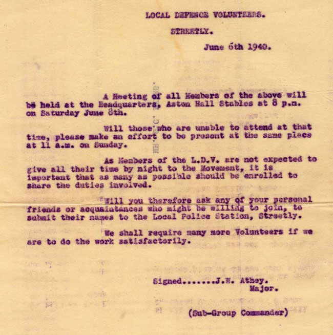
2. THE
1940 MARK-UPS
This map belonged to my
own father who was C.O
of one of the three
local Home Guard
platoons (originally
L.D.V - "Local Defence
Volunteers) which was
based at
Little Aston
Hall Stables.
Here is the
background to this bit
of Streetly's history in
1940.....
These L.D.V. platoons were
formed at the very first
assembling of local
volunteers in the early
days of June, 1940
following
Anthony Eden's
wireless appeal on the
evening of May 14th.
The prospect of
invasion, previously
unthinkable, had
suddenly become real and
threatening as Holland,
Belgium and now France
reeled in the face of
Hitler's blitzkrieg
which was
approaching ever closer
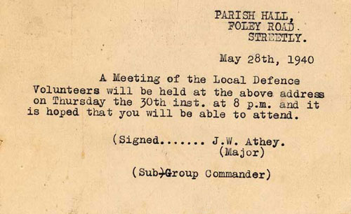
to the Channel coast. Here is how it came
about, in my father's
own words, written in
1944/45:
The initial
formalities
are over.
Eden has
broadcast (Read
the text
here) and
within the
hour the
local police
have been
besieged by
eager
enquirers
for
enrolment
forms.
Our
detailed
life
histories
have been
submitted
and,
presumably,
vetted. A
lot of
organising
work has
been done
behind the
scenes by
our Sub
Group
Commander
and his
Second in
Command, and
a
preliminary
meeting of
would-be
Local
Defence
Volunteers
has been
held in our
Parish Hall.
 And
now on a day
of early
June 1940,
we parade
(or perhaps
"gather"
would be a
more
suitable
term) at
Little Aston
Stables
and find our
names
amongst a
list of men
who are
destined to
form a
platoon of
the L.D.V.
And
now on a day
of early
June 1940,
we parade
(or perhaps
"gather"
would be a
more
suitable
term) at
Little Aston
Stables
and find our
names
amongst a
list of men
who are
destined to
form a
platoon of
the L.D.V.
A roll call,
more filling up
of forms. The
Platoon
Commander is
chosen after a
query by the
Company
Commander: "Any
man here with
army experience
and who has a
car?" A few
minutes later,
an infantry
private of the
last war takes
his first
parade. N.C.Os.
are created by
similar methods.
We can take no
risks at this
stage and all
section leaders
must have
previous Army
training.
The Platoon
falls in.....
|
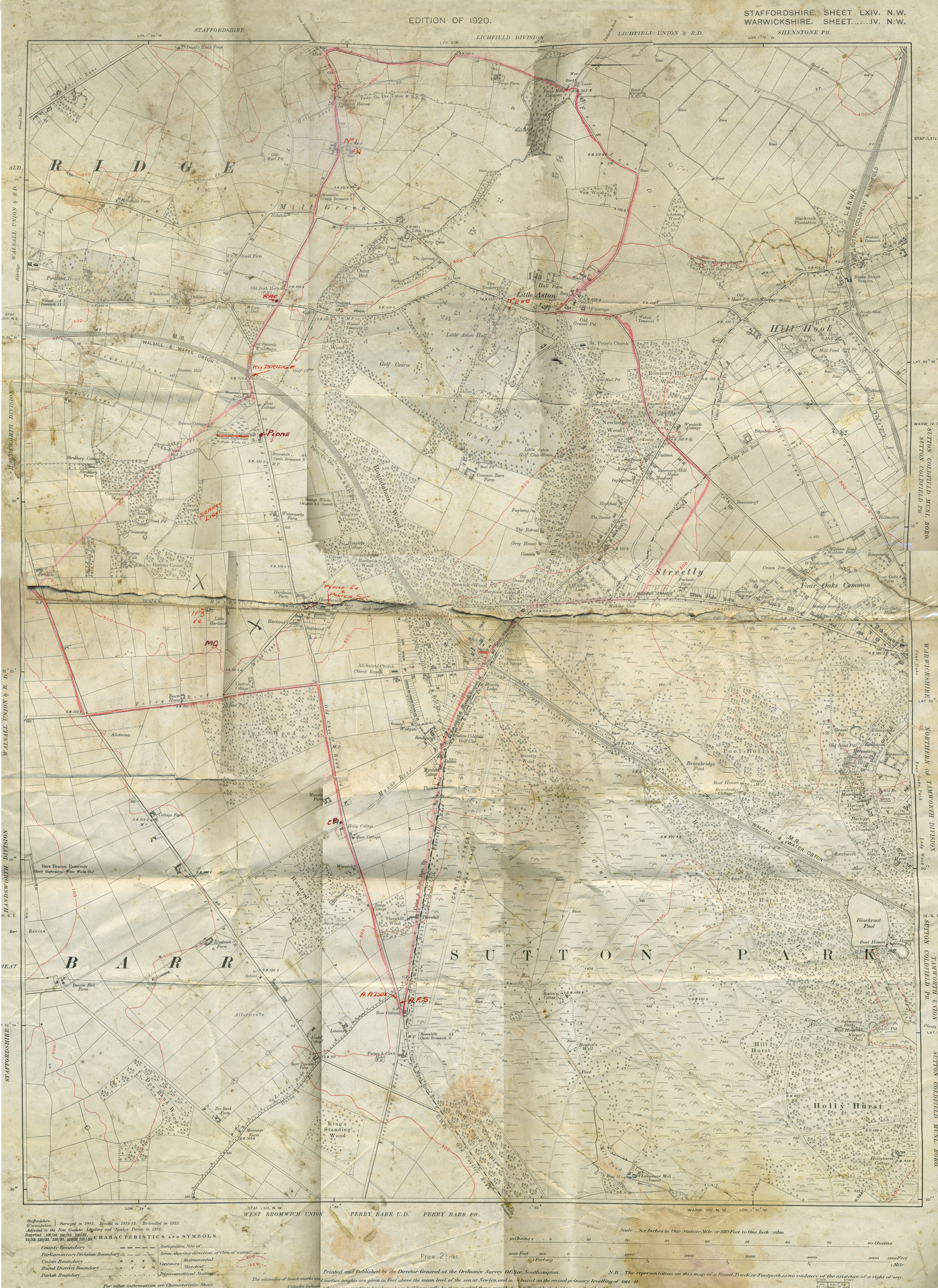
Back to the map....
Although my father seems to
have owned it, it was
marked up by someone
other than him, in
perhaps June or July,
1940 and in a rather
haphazard manner, to
show what was felt
important in defence of
the local area. The red outline
shows the area of
responsibility for one
of the Companies in the
32nd Staffordshire (Aldridge)
Battalion Home Guard,
the unit formed to
defend this part of
South Staffordshire. It is "B"
Company of that
Battalion of which the
three Streetly/Little
Aston platoons were
part, each comprising perhaps 40
or 50 men, all
volunteers at that time.
I'll work clockwise
around the map,
clarifying the
annotations, starting
from the bottom near to
the
Parson and Clerk.
The first thing to note
is the emphasis on
availability of phones –
few of the men had a
landline at home and
only those with an
interest in science
fiction would have
conjured up the vision of
a mobile phone in
their battledress pocket. So we
see an
AA box (which
contained a phone) at
the bottom of the map.
Also mention of an
A.F.S. depot (Auxiliary
Fire Service). (Where was
that located, precisely,
and in what suitable
building?)
Going on up
the
Chester Road, there
is, surprisingly, no
mention of the road
block located a few
yards further up, after
Queslett Road
 (which I
clearly remember seeing
from around that time in
the form of a pile of
rusty cars and other material on the verge,
ready to be shoved
across the road).
Perhaps the map even
predates those makeshift
defensive measures. On
the far corner of
Bridle
Lane - perhaps
Puddepha's corner shop
(later
Slim's) -
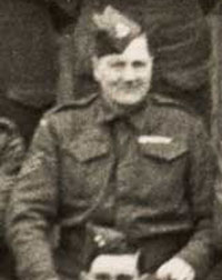
C.B. Mr. Puddepha
(right)
was
a senior NCO in No. 2
Platoon; but even though
there are some military
terms which can be
abbreviated in this way,
the most likely
interpretation is
"Call Box" - in other
words, a public
telephone kiosk. (which I
clearly remember seeing
from around that time in
the form of a pile of
rusty cars and other material on the verge,
ready to be shoved
across the road).
Perhaps the map even
predates those makeshift
defensive measures. On
the far corner of
Bridle
Lane - perhaps
Puddepha's corner shop
(later
Slim's) -
C.B. Mr. Puddepha
(right)
was
a senior NCO in No. 2
Platoon; but even though
there are some military
terms which can be
abbreviated in this way,
the most likely
interpretation is
"Call Box" - in other
words, a public
telephone kiosk.
If we look at
Foley Road
(now Foley Road West)
there is the designation
M.G. between there and
Hardwick Road. That was
Streetly's own
anti-aircraft battery -
well, more precisely, a
large machine-gun
mounted on a tripod.
This was manned for
extended periods by one
particular gentleman, no
doubt with the asistance
of others, but there is
no record of the extent
to which it was fired in
anger. Images of it -
and him - survive
(below).
.jpg) |
.jpg) |
.jpg) |
.jpg) |
.jpg) |
This
gentleman seems to be the Company
expert on the subject of machine
guns, and especially the Lewis gun.
He remains unidentified and
staffshomeguard would dearly like to
put a name to a face. Could he be
Mr Ralph
of
Middleton Road?
He
deserves to be honoured and
commemorated. Can any visitor to
this page help us, please? |
|
Not far away, across the
field in
Little Hardwick
Road, is
HQ,
No. 3
Platoon which no doubt
had responsibility for
the anti-aircraft machine-gun. Around
there, later on, a
sandpit had been
converted into a firing
range for rifles and
machine guns. (I saw it
in operation one Sunday
morning and was deeply
impressed!). Perhaps the
.jpg) HQ
was located in a shed
there, or an adjacent
house. HQ
was located in a shed
there, or an adjacent
house.
Nearby fields
have a large cross
marked on them in black. No
interpretation is
attempted for that - but
the areas marked MIGHT coincide
with the sandpit/future
rifle range on the same
side of the road
(seen in use, left); and,
on the opposite side, with a future
HG training area
located, it is thought, where
the O.V. sports field is
now.
Continuing down the
Chester Road there is a
Searchlight unit
located in open fields
to the left
(mentioned
in
another
Streetly memoir)
and then two
Vulnerable Points which
needed guarding - the
South Staffordshire
Water Company's
Pumping Station (with its
telephone) and the
railway bridge.
Further on
still, there is an
RAC
telephone adjacent to
the
Irish Harp and
beyond that, probably at
Mill Green Farm, the
H.Q. No. 1 Platoon,
hosted by
Mr. and Mrs.
Foden whose three sons
were members. An
artillery range for
spigot mortar training would be
created there, but not
until later.
To the
south-east, the
H.Q.
No. 2 Platoon is
located in the stables
at Little Aston Hall. (This Platoon was later
renamed no. 5 and its
creation and ensuing
life was described in a
wonderful 1944/45 memoir
by its C.O. which
can be read here).
Returning to the
Hardwick crossroads,
there is no mention of
the
defensive
position/air raid
shelter created there by
the Home Guard in the
winter of 1940/41, after
this map was marked up
(which suggests the
latter had been
superseded by something
else, rather more
detailed and
professional, perhaps).
The building of this is
recorded in images,
below.
.jpg) |
.jpg) |
.jpg) |
.jpg) |
.jpg) |
| The
one on the left is rather later,
perhaps by two or three years, and
the shelter is now part of the landscape. It
is still wartime - note the blackout
mask on one of the car's headlamps.
The photo was taken from near Cutler's
petrol pumps. |
|
In
Hardwick Road
itself, the locations of
the
Telephone Exchange
and the
Police Station
are noted.
And
finally, in the village
itself, just the
railway station
gets a mention, with
nothing more of note
marked all the way along
the
Thornhill Road,
back to the
Parson & Clerk. |
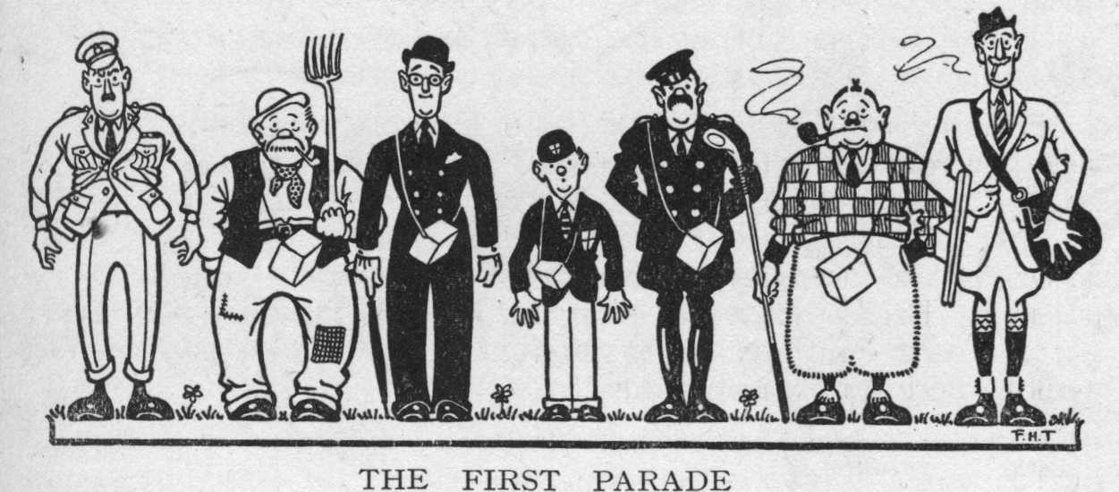
In conclusion, here is another map of
the area, a jokey
depiction of
"The Ground
We Defend" by the 32nd
Battalion Adjutant,
Frank Timings, an
urbane ex-regular
officer who served in
the Battalion throughout
and was well-known for
his artistic skills.
The latter are to be
seen throughout
"Home Guarding" -
the 32nd Battalion
commemorative record
which Frank edited.

And a similarly
light-hearted
description of the
broader area within
which Streetly sits,
written in 1944/45 by
Lt. W. Oakley
from the perspective of
the local defenders and
also appearing in
"Home Guarding"
:
JUST a
slice of Staffordshire, a county which a former king - one
of the James's, I believe - said was only fit for being cut
up to make roads. Little he knew about it, for our county
is as varied in its scenery, history, and occupations as most,
and the slice we defend is worthy of the whole.
Our history goes back to the
dawn of civilisation in this country. True, it is unwritten
history, but the evidence is here for all to read who will.
Some of you have trained and sited strong points and machine-gun
posts on the fern-covered slopes, which once were
Knaves Castle
and the Old Fort at
Upper Stonnall.
Hills were just as important
strategically, when slings and boulders were the weapons,
as they are to-day, and for probably two thousand years or
more those entrenchments have mounted guard above the
Old
Chester Road.
Not so certain, but equally interesting,
is the tradition attaching to our most prominent landmark,
the solace of all prentice mapreaders,
Barr Beacon, for "this
most central hill in England" so it is said, was the
scene of the Druids' great midsummer festival.
Aldridge, then, must have
been as important to the "parsons" of those times as York or
Canterbury are to-day! Moreover the Arch-druid
liked the air of Aldridge so well that he had his "palace"
here and Druid's Heath was
his address.
Be that as it may, there is no doubt that the road from the
Beacon, along the ridge, down
Whetstone Lane towards
Walsall
Wood, would be one of the earliest trodden by men in our area.
It would join up with the Watling Street, that ancient military
highway which the Romans perfected and which our
Brownhills
Home Guards know so well.
They, too, will remember the old signpost which stood at
the junction of the Watling Street and
Old Chester Road, a
relic of the "good old days" of stage coaches and
highway robbery. One of the past masters at this game
was Tom King, who, again according to tradition, was born
at the "Irish Harp", that snug little inn, not unknown
to the 32nd Battalion, which one likes to believe has not
altered a brick since Tom took to the road, and which, one
fervently hopes, never will.
Tom
King was by no means the only one to ply his trade on the
neighbouring heaths of Barr, Pelsall, Brownhills and Aldridge.
Aldridge Heath, lying on the old road between Birmingham and
Stafford, was particularly notorious. It is recorded
that on January 30th, 1703, the Shrewsbury coach was robbed
there and three attorneys later the same day, though one of
them managed to retain a refresher of twenty guineas by stuffing
it into the toe of an old boot he had in his bag. Next
month two drovers, returning from Newcastle Fair were robbed
and killed, and two days later the High Sheriff himself, returning
from Lichfield, was robbed of sixty guineas. That sealed
the gang's fate, for the Sheriff had them hunted down and
strung up just to "larn 'em".
In 1746 came
John Wesley, on horseback across
Aldridge
Heath on his way from Birmingham to Stafford. It was
raining when he left Birmingham early one morning and by
the time he had reached our perilous neighbourhood, always
a tough nut for the "invader" to crack, it had
turned to snow. A cheerful native told Wesley it was
a thousand pounds to a penny he wouldn't reach Stafford
that day, for even on a clear day he was "not sure
to go right across" the common. But Wesley was
no ordinary paratroop and at following a trail he must have
been real hot stuff, for he records in his diary: "However
we went on and I believe did not go ten yards out of our
way till we came to Stafford". No doubt he passed
his map-reading proficiency test first time.
Brownhills Common
and Pelsall Common are all that is left to remind us of those
spacious days, and we are very glad to have them in our slice
of Staffordshire.
Of notable buildings still standing, perhaps
Rushall Hall
is the most interesting. The present hall, or a large
part of it dates from 1402, though the site seems to have
been occupied continuously since Anglo-Saxon times and in
Domesday Book the Manor of Rushall was valued at ten shillings
a year. (Aldridge was worth fifteen shillings).
Rushall Hall played a lively part in the war between Charles
and Parliament. Both sides occupied it in turn, but
the Royalists seem to have held it most of the time and
used it as a sort of base depot for storing plunder taken
from convoys passing between London and Lancashire.
Anyway when it was finally taken for
Cromwell's side by
the Earl of Denbigh, ably assisted by the then 32nd Battalion
(!) and their Walsall comrades in arms, in May 1644, the
recovered property was valued at £10,000. No doubt
the respective Comforts Funds benefited accordingly.
And so one could go on - about the
Blue Hole and
Linley
Caverns (from which the Romans took limestone to build their
fort at
Wall on the
Watling Street), about
Frank James,
Hobshole, Little Aston Hall, Shire Oak, Catshill, Bourne
Vale - but perhaps I've said enough to convince all reasonable
men that we of the 32nd have cause to be proud of the ground
we defend.
*******************
|
This
family and local history page is
hosted by
www.staffshomeguard.co.uk
(The Home Guard of Great Britain, 1940-1944)
Please see INDEX page for general acknowledgements.
Grateful acknowledgement
is made
to Kate Cutler, whose father, Bill Cutler, took the
images showing the machine gun
and the building
of the air-raid shelter shown on this page.
All
other text and images are,
unless otherwise stated, © The Myers Family 2022
|
INDEX
Home Guard of
Great Britain
website |
 |
INDEX
Streetly and Family Memories
1936-61
|
L8L
June 2022


| | |